
Loughsalt Mountain [Cnoc an Liathain]
Good walks are even better shared.
Overview
Loughsalt Mountain [Cnoc an Liathain]
Overview
Loughsalt Mountain is an impressive peak nestled in the Northwest Highlands of Ireland. With an elevation of 558 meters, it is a perfect destination for those looking to explore the breathtaking scenery of Donegal while getting a good workout. It carries the classification of a Marilyn, which is a hill with a prominence of at least 150 metres.
Geology
The mountain's geology is predominantly Old Red Sandstone, distinguishing it with a unique reddish tint. The rocky outcrops present a historical narrative of earth’s past, occasionally revealing fascinating fossils. Who knows what prehistoric creatures might have roamed these slopes?
Routes
One of the most popular routes to the summit begins at Loughsalt Pass. This pathway is well marked and provides both novice and experienced hikers with a moderate challenge as they make their way up. The total distance is approximately 6.4 km and typically takes about 2.5 hours to complete, depending on your pace. Don’t forget to stop and take in the extraordinary views!
Summit Features
The summit of Loughsalt Mountain features a sturdy trig point and a small stone cairn, marking the pinnacle of your ascent. It’s a popular spot for hikers to rest and revel in the panoramic views of the surrounding landscape.
Terrain
Expect a mixture of rocky and grassy trails, which can become quite boggy in wet conditions. Good footwear is essential, and perhaps even a sense of adventure, as you navigate the varied terrain.
Views
From the top, hikers are treated to spectacular sights, including Lough Swilly and Tory Island in the distance. Horn Head can also be seen, rising dramatically from the Atlantic Ocean. The best views tend to emerge in spring and early autumn, when nature showcases its most vibrant colours.
Hazards
While the hike is mostly straightforward, pay close attention to your footing as some areas can be slippery. The boggy conditions in certain spots can catch you off guard, so consider investing in a good pair of hiking boots before your adventure.
Nearby Summits
Adjacent to Loughsalt, you can explore other nearby peaks such as Mullaghderg Mountain (440 meters) and the towering Sliabh Liag (601 meters), both of which offer additional hiking opportunities.
Access
Loughsalt Pass serves as the primary access point for parking, which accommodates several vehicles. For those relying on public transport, the nearest bus stop is over 8km away in Carrigart, from where taxis can be acquired to reach the trailhead. Be sure to prepare your journey in advance!
Facilities
While there are no facilities directly on Loughsalt Mountain, the nearby village of Carrigart provides small cafes and essential amenities including public toilets. Perfect for a post-hike treat!
History
The Irish name, 'Cnoc an Liathain', translates to 'Hill of the Grey', likely indicative of its rocky appearance. This majestic peak is not just a physical feature; it is also steeped in local folklore about ancient explorers and mythical heroes.
In summary, Loughsalt Mountain is an enchanting destination for outdoor enthusiasts craving both adventure and scenic beauty. So pack your bags, grab your camera, and get ready for a day of exploration!
Explore routes near Loughsalt Mountain [Cnoc an Liathain]
Public walks starting within 80 km of this hill. Nearby does not mean a route reaches the summit; check its map and access before setting out.
Derry~Londonderry City Walls Circuit
View route
Banagher Glen and Forest: complete higher-return circuit
View route
Route planning notes
These notes describe possible approaches, not verified navigable routes or permission to cross land. Check current paths, local access rules and conditions before setting out.
Loughsalt Pass Route
A well-defined path that begins at Loughsalt Pass and winds its way up the mountain, offering stunning views along the way.
Make a day of it, together
Find someone to share the walk with, or organise a day out along a route you like.
Hill facts and local notes
Classifications
Elevation
469m
1,539 ft
Prominence
354m
Coordinates
55.0855, -7.7922
C133264
OS Map
02
At the Summit
The summit boasts a prominent trig point and a small stone cairn. On a clear day, visitors can survey the glorious surrounding landscape and appreciate the sense of achievement.
Terrain & Geology
Loughsalt Mountain is primarily composed of Old Red Sandstone, giving its slopes a unique reddish hue. This geology is fascinating as it houses various fossilised remnants, indicating a rich prehistoric environment.
Views & Scenery
The view from the summit includes Lough Swilly, Tory Island, and the rugged Donegal coastline. On the other side, the majestic Horn Head is also visible.
History & Heritage
Name Origin
The name 'Cnoc an Liathain' translates to 'Hill of the Grey' in Irish, possibly referring to the mountain's rocky appearance.
Historical Significance
Loughsalt Mountain holds a special place in local folklore, being steeped in legends of ancient warriors and mythical creatures.
Getting There & Facilities
Check current local access restrictions, parking rules and transport timetables before travelling. These notes do not confirm public access to the summit.
Parking
Parking is available at Loughsalt Pass, which can accommodate several cars. It is easily accessible via the C road.
Public Transport
The nearest bus stop is in the village of Carrigart, approximately 8km away, from where a taxi may be necessary to reach the trailhead.
Nearby Facilities
There are no facilities at the mountain; however, Carrigart offers small cafes and basic amenities including toilets.
Safety Information
Known Hazards
- Watch out for slippery rocks, especially after rainfall. The terrain can become boggy in the valleys, so sturdy footwear is a must.
General Safety Tips
- Check weather conditions before setting out
- Carry appropriate clothing and equipment
- Let someone know your planned route
- Take a map, compass, and GPS device
- Carry emergency supplies: food, water, first aid kit, torch
Hills
Some common questions about the hills answered
Are there group walks up Loughsalt Mountain [Cnoc an Liathain]?
Many walkers use Walkmates to join or organise walks with others. You can check for group walks around Loughsalt Mountain [Cnoc an Liathain] through the maps
Are there other walkers around Loughsalt Mountain [Cnoc an Liathain]?
Activity varies by location and time, but Walkmates lets you see whether others have shared walks or shown interest in this area. Find other people through the walking friends search walking friends for Loughsalt Mountain [Cnoc an Liathain] search or of course create your own walk for Loughsalt Mountain [Cnoc an Liathain]
Can I organise a walk to Loughsalt Mountain [Cnoc an Liathain]?
Yes. If there aren’t any walks listed already, you can create a walk and make it available for others to join.
If you're signed up to Walkmates, you can create a walk to Loughsalt Mountain [Cnoc an Liathain].
How do I find a walk up this hill?
There are often multiple ways to walk this hill, depending on experience and route preference. Walkmates helps you explore walks and routes that others have shared.
Can I suggest a new route up Loughsalt Mountain [Cnoc an Liathain]?
Yes. You can suggest or create routes to share with others. Walkmates focuses on the social side of walking, so routes are used to help people organise walks and explore areas together, rather than as detailed navigation tools or route libraries.
Other uses really appreciate knowledgeable walkers sharing their routes. Share your favourite route to Loughsalt Mountain [Cnoc an Liathain] here
The is an error or something incorrect about this hill. How do I let you know?
We always strive to keep the information on Walkmates as accurate as possible. If you find an error, please let us know through the contact form and we'll aim to correct it as quickly as possible
Community Discussion
Comments
Location
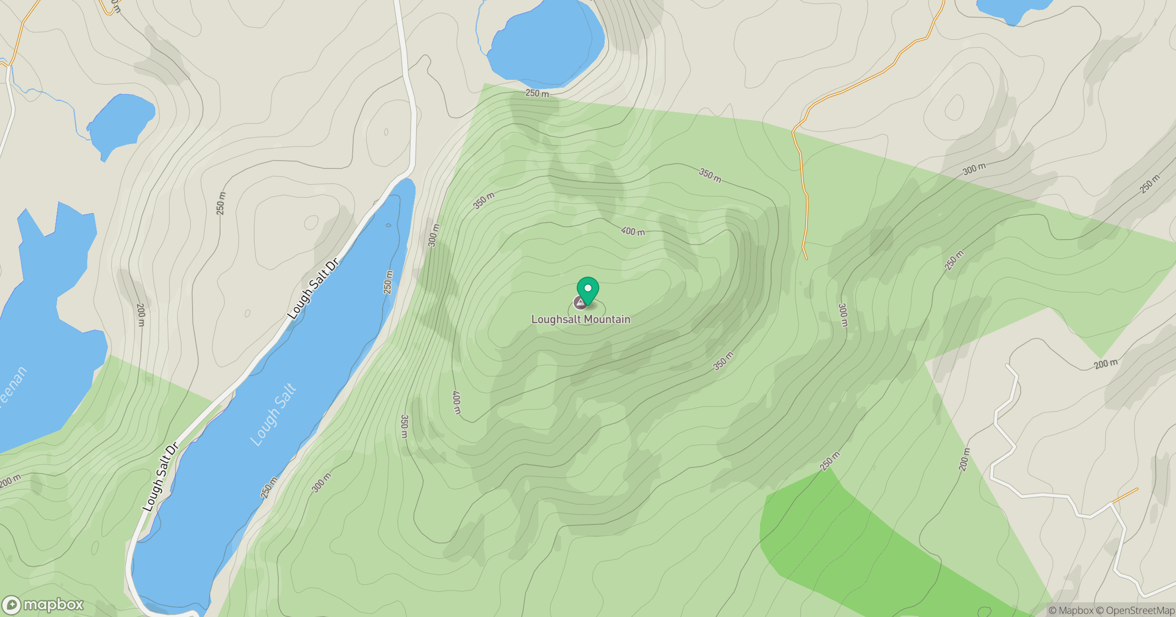
Grid reference: C133264
View on OpenStreetMapOpens a map in a new tab, centred on the hill.
Hills within 30 km
Straight-line distance, not a walking route or confirmation of access.
No comments yet. Be the first.